64
| SUNRAYS MAY 2015
ONLINE:
SCTEXAS.ORG
Depending upon the season, a hat and
insect repellant can come in handy. Given
the trail’s isolation, individuals should
hike with a friend and carry a cell phone
in case of emergencies. To ensure that
the experience is an enjoyable and safe
one, each hiker is encouraged to evaluate
his and her own fitness and endurance
levels when selecting a route. Maps of
the Good Water Loop are available at
the Corps’ Project Office during business
hours and online.
The Randy Morrow Trail, formerly
known as the San Gabriel River Trail,
is a Georgetown city trail. The trail
runs from Booty’s Road Park at Lake
Georgetown to San Gabriel Park.
Information about the trail can be found
on Georgetown’s website or obtained
through the city parks department.
Visitation records for Lake Georgetown
attest to the popularity of this local
recreational gem. According to Lake
Manager Scott Blank, more than
337,000 vehicles entered Corps property
in 2014 alone. Trail runners, hikers,
mountain bikers, birders, geocachers,
youth and Scout groups, campers,
hunters, fishermen and kayakers alike
gravitate to the lake and its surrounding
woodlands.
Whether you opt for a leisurely sunset
view from the lake or choose an easy or
ambitious hike, the scenic destination
of Lake Georgetown and outstanding
trails are just down the road, waiting
to be explored.
Discovering a River Valley
The San Gabriel River, whose north
fork was dammed to form Lake
Georgetown, has a rich historical past.
While evidence indicates humans first
pursued mammoth, bison and other
large mammals in the San Gabriel
River Valley at least 10,000 years ago,
recorded history of the area did not take
place until the arrival of Europeans 300
years ago. Much has changed since the
Tonkawa Indians camped along the
banks of the crystal clear river. The
Tonkawa called the area Takachue
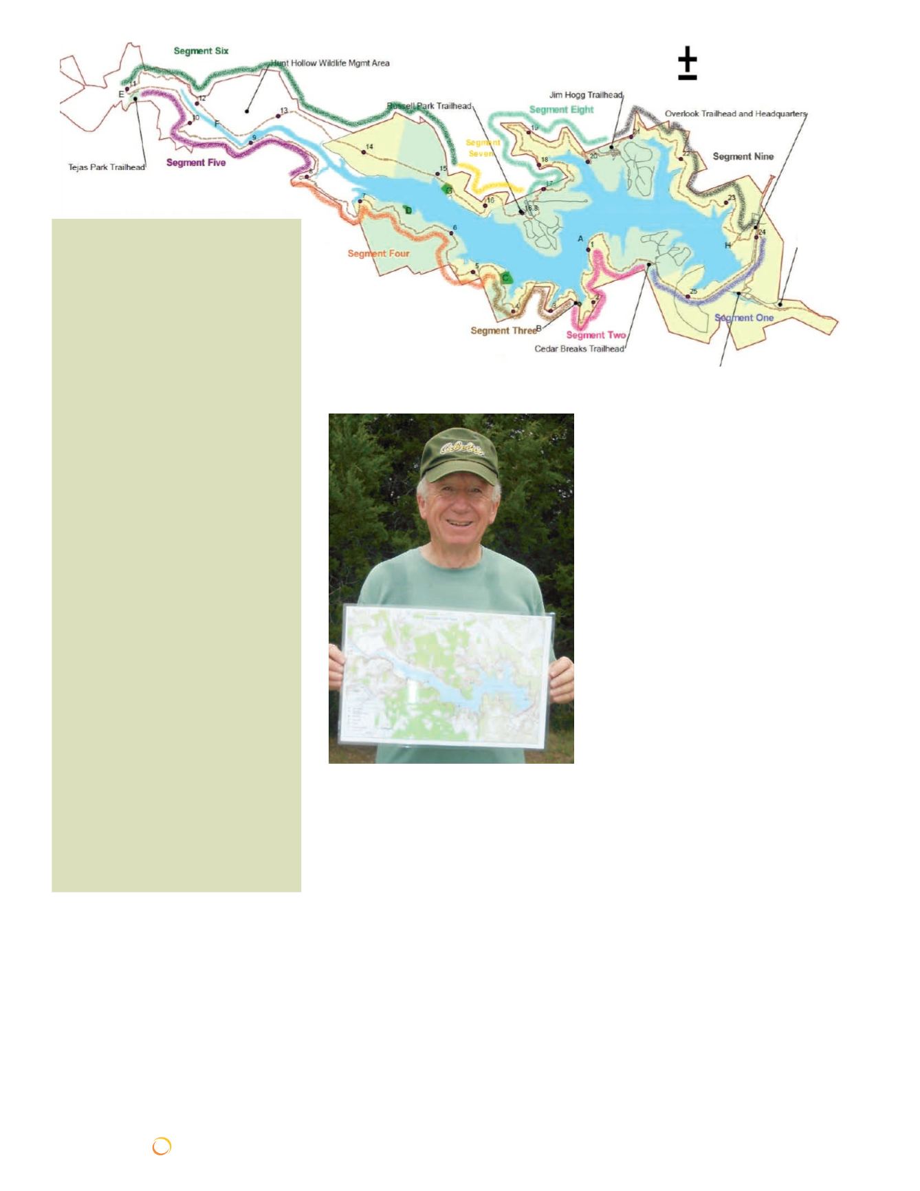
Good Water Loop at Lake
Georgetown
Hike Segments
Segment One
Overlook Park to Cedar Breaks
Park
4.5 Miles (round-trip)
Segment Two
Cedar Breaks Park to Crockett
Gardens
5 Miles (round-trip)
Segment Three
Lost River to Crockett Gardens
4.5 Miles (round-trip)
Segment Four
Lost River to Mile Marker 8
6.5 Miles (round-trip)
Segment Five
Tejas Camp to Mile Marker 8
6 Miles (round-trip)
Segment Six
Tejas Camp to Walnut Springs
8 Miles (round-trip)
Segment Seven
Russell Park to Walnut Springs
4 Miles (round-trip)
Segment Eight
Jim Hogg Park to Russell Park
7.5 Miles (round-trip)
Segment Nine
Overlook Park to Jim Hogg Park
7 Miles (round-trip)
Above: By offering day hikes through-
out the year along nine different seg-
ments of the Good Water Loop, the
Hiking Club has motivated its members
to explore the entire route in manage-
able increments of four-to-eight miles.
Left: Gary Massaglia displays the trail
map he and twenty-two other Hiking
Club members have received after
completing all nine segments in the
Good Water Loop Hike Series.
Continued from the previous page
Booty’s
Crossing
Trailhead
and City of
Georgetown
Challenge
Course
Stilling Basin Trailhead


